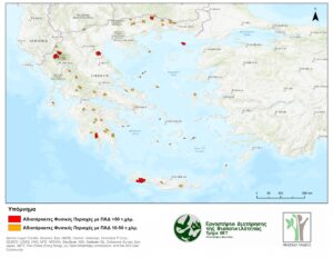
The output of our research is available as an open map in Google Earth (see research outputs – databases -v2) and suggestions on the use of the national roadless map of Greece in national environmental policy and legislation are included in the policy brief-2022 (Research outputs-Policy briefs). Here we show only the large undisturbed natural areas over 10 sqm for visualization reasons.
The below inventory includes 55 roadless areas of Greece over 10 sqkm. The natural undisturbed areas without roads (AFP) are presented, i.e. the roadless areas (RAs) with their buffer zone of one km, with decreasing order in terms of AFP size. Their overlap with Natura 2000 is noted (%) and whether the area is in the mainland (H) or in an island (N) or/and an island completely without roads N-NAFP. The areas that have already been protected through Ministerial Decisions as roadless areas are noted and, in this case, the protected area (sqkm) is presented.
| Η/Ν | Name RA-AFP | Area (sqkm) | Natura (%) | Protected |
| Ν | Mount Lefka ori | 382,06 | 96,93 | Yes |
| Η | Mount Tymfi | 202,75 | 96,55 | Yes |
| Η | Mount Olympos | 169,9 | 78,0 | |
| Η | Mount Taygetos | 143,23 | 100,00 | Yes |
| Η | Aetorachi-Nestos | 107,34 | 100,00 | |
| Η | Mount Smolikas | 102,89 | 99,27 | Yes |
| Ν | Mount Saos | 97,30 | 99,89 | Yes |
| Η | Mount Chionovouni | 95,73 | 37,13 | |
| Η | Mount Menoikio | 70,5 | 100,0 | |
| Ν | Mount Dikti | 69,3 | 100,0 | |
| Η | Mount Parnassos | 66,7 | 100,0 | |
| Η | Mount Phalakro | 66,6 | 90,1 | |
| Η | Arkoudorema-Flega-Avgo | 56,88 | 94,45 | |
| Η | Kompsatos river-Thrakika Meteora | 54,25 | 63,73 | |
| Ν | Mount Pelinaio | 53,99 | 100,00 | |
| Η | Mount Erymanthos | 53,84 | 100,00 | |
| Η | Dytika Agrafa | 53,64 | 100,00 | |
| Η | Mount Grammos | 52,33 | 100,00 | |
| Η | Parnonas (southeastern side) | 51,57 | 88,15 | |
| Ν | Mount Pyksarias | 51,38 | 100,00 | |
| Η | Mount Chelmos | 50,49 | 100,00 | |
| Η | Ktenias-Nestani | 47,21 | 19,34 | |
| Η | Mount Gkiona | 46,68 | 99,40 | |
| Η | Mount Chatzi | 45,61 | 98,40 | Yes |
| Η | Mount Mainalo | 44,98 | 100,00 | |
| Η | Frakto-Achladorema | 44,78 | 100,00 | |
| Η | Thrakika Meteora-Lykotopos | 44,07 | 69,37 | |
| Η | Polydroso-koryfi Psari-Kosmas | 43,81 | 100,00 | |
| Η | Mount Chelidona | 42,98 | 0,00 | |
| Η | Mount Papikio | 42,87 | 40,59 | |
| Ν | Mount Psiloreitis | 42,61 | 100,00 | |
| Ν | Kastri-Imerovigli | 39,91 | 0,00 | |
| Η | Mount Achladovouni | 39,46 | 0,00 | |
| Η | Rodopi-Koula | 37,93 | 66,09 | |
| Η | Mount Kaliakouda | 37,41 | 0,00 | |
| Η | Gyftissa-Tampouri | 37,41 | 0,42 | |
| Η | Mount Athos | 36,41 | 100,00 | |
| Ν | Mount Kochylas | 35,53 | 95,00 | |
| Ν | Amorgos (northeastern side) | 34,64 | 72,66 | |
| Η | Nedonas river (wider region) | 33,58 | 17,55 | |
| Η | Mount Voras | 33,51 | 100,00 | |
| Η | Mount Orvilos | 32,69 | 57,81 | |
| Η | Mount Panaitoliko | 31,55 | 96,66 | |
| Η | Mount Pinovo | 30,21 | 100,00 | |
| Ν | Mount Kantili | 28,45 | 100,00 | |
| Ν | Kyra Panagia | 19,67 | 100,00 | |
| Ν | Saria | 19,55 | 100,00 | |
| Ν | Psilo Petali | 18,68 | 88,17 | |
| Ν-NAFP | Gyaros | 17,51 | 100,00 | |
| Ν | Polyaigos | 17,15 | 100,00 | |
| Ν-NAFP | Keros | 15,18 | 100,00 | |
| Ν-NAFP | Peristera | 14,13 | 100,00 | |
| Ν | Ydra (eastern side) | 13,80 | 0,00 | |
| Ν | Dokos | 12,95 | 0,00 | |
| Ν-NAFP | Gioura | 11,05 | 100,00 |
Red polygons indicate very large natural undisturbed areas over 97 sqkm (PAD category >50 sqkm). Orange polygons indicate large natural undisturbed areas from 11 to 96 skqkm (PAD 10-50 sqkm)