Project

ROADLESS

Project info

Title
ROADLESS - Roadless Αreas and sustainable development in Greece
Year
2019 - 2020
Funding
Coordinator
Collaborators
Project team

Assoc. Prof. Vassiliki Kati, scientific coordinator

Antonia Galani, project coordinator

Dr. Christina Kassara, biologist

Dr. Haritakis Papaioannou, biologist

Dr. Olga Tzortzakaki, biologist

Maria Psaralexi, biologist, PhD student (AUTH)

Maria Petridou, agronomist, PhD student (BCL/UOI)

Monika Hoffmann, forester, PhD student, Polish Academy of Sciences

Title
NATLAND - Undisturbed natural areas of Greece (SEBI 13)
Year
2021-2022
Coordinator
Project team

Prof. Vassiliki Kati, scientific coordinator

Antonia Galani, biologist            

Dr. Christina Kassara, biologist

Dr. Haritakis Papaioannou, biologist

Dr. Olga Tzortzakaki, biologist

Maria Psaralexi, biologist, PhD student (AUTH)

Maria Petridou, agronomist, PhD student (BCL/UOI)

Dimitris Gotsis, Engineer

Stratos Papantoniou, MSc student (BCL)

Goal

Halt landscape fragmentation from road sprawl and the consequent biodiversity loss in natural ecosystems in Greece

Research questions

Why such research?

It is not by coincidence that the biodiversity crisis era happens at the same time with the most explosive road sprawl in human history. With the length of paved roads projected to increase at a magnitude of 60% by 2050, road sprawl is a key driver triggering or accelerating land use change, which is recognized to be the top threat for biodiversity decline globally and in the EU. On one hand, road infrastructure is known to promote economic growth and human welfare, but on the other hand it causes land use change, fragmentation, increase of artificial land, chemical pollution, hydrological disruption, soil erosion, acceleration of biological invasions, animal mortality, overexploitation of natural resources and other often irreversible negative impacts to wildlife and ecosystem functioning. Humanity is dependent on biodiversity and ecosystem services and hence threatened by their collapse. The conservation of roadless areas (RAs) is recognized as a cost-effective and efficient tool to preserve biodiversity and its benefits for humans.

According to a recent report of the European Environmental Agency, Greece is less fragmented than the rest of Europe but presents higher rates of fragmentation increase. We evaluate the fragmentation intensity of Greece in terms of RAs number and extend. RAs are those land patches over 1 km2 that are at least 1 km away from the nearest road. We work in the science-policy interface suggesting the legal conservation of large RAs and roadless islands are wilderness areas of high ecological, natural and aesthetic value that they should be preserved from degradation and fragmentation.

Actions

BCL has undertook two projects (ROADLESS, NATLAND) to deliver the national roadless map of Greece, update the SEBI 13 European indicator, and provide scientific evidence and guidelines for incorporating roadless areas in national environmental policy and planning.

ROADLESS project activities:

  • Road mapping and delineation of extended RAs (over 50 km2) using GIS
  • Spatial data analysis of roadless areas polygons vs the Natura 2000 network
  • Ecological modeling to assess the contribution RAs to the conservation of wild fauna, taking as a case study the Balkan chamois (Rupicapra rupicapra balcanica) population in Tymfi mountain (species protected by the Habitats Directive 92/43/EC)
  • Synthesis of results in a final report on the use of extended RAs in the national environmental planning
  • Public awareness and result dissemination activities to the scientific community (databases, papers) and to policy makers and society (website, popular science, online questionnaire, policy brief, video spot)


NATLAND project activities:

  • Road mapping and delineation of all roadless areas in Greece above 1 km2
  • Identification of roadless islands of any size
  • Update of the European Indicator SEBI 13 for Greece “Fragmentation of natural and semi-natural ecosystems”, and of the relevant chapter in the national environmental state outlook
  • Synthesis of research outputs in a final report on the use of undisturbed natural areas (roadless areas and their buffer zone of 1km) in national environmental policy and planning
  • Public awareness and result dissemination activities to policy makers and society (website, popular science, policy brief, webinars)


Results

Databases

No Description
No Description

Publications

Balkan chamois (Rupicapra rupicapra balcanica) is a protected species with an Inadequate-Bad (U2) conservation status in Greece. Our study explores its seasonal range use pattern, demography and habitat selection in a site of the Natura 2000 network, Timfi Mountain. To this aim, we examined 1168 observations obtained from six seasonal surveys (2002: four seasons, 2014 and 2017: autumn) and performed an ecological-niche factor analysis (ENFA), using 16 environmental and human-disturbance variables. The species had an annual range of 6491 ha (25% of the study area), followed the typical range-use pattern, and presented the minimum core area during the rutting season (autumn). Timfi Mt hosted 469 individuals in 2017 (the largest population in Greece), increasing by 3.55 times since 2002. The species selected higher altitudes during summer and autumn, pinewoods over broad-leaved woods as winter grounds, and it avoided south-facing slopes. Our results supported the anthropogenic risk avoidance hypothesis; the species always selected remote areas away from roads, human settlements, and hunting grounds. In Greece, 40% of its distribution area falls within hunting ban areas (16.5% of the country). A national conservation policy is needed towards maintaining and increasing roadless areas and hunting-ban areas within Balkan chamois range nationwide.
Land use change poses as the top threat for biodiversity decline, and road sprawl as a key driver behind it globally. According to the recent Landscape Fragmentation Indicator (LFI), Greece is less fragmented than the rest of Europe but presents higher rates of fragmentation increase. We developed the Roadless Fragmentation Indicator (RFI) to monitor fragmentation in more natural ecosystems. The RFI calculates the percentage of land that is covered by roadless areas (RAs), defined as land patches over 1 km2 that are over 1 km away from the nearest road. We produced the roadless map of Greece, concluding to 1115 RAs ranked by size (1–256 km2) and to a national RFI of less than 5%. The RFI reflected naturalness, was significantly higher in the Natura 2000 network, and was more sensitive in less fragmented zones. Six mountains (0.51% of Greek land) have remained largely roadless (RAs ≥ 50 km2) and should be protected as such. We call for a straightforward roadlessness policy under a “European Roadless Rule” that would legally protect at least 2% of European land as road-free area. We also call for no further unjustified road sprawl in more natural and least fragmented ecosystems, as a measure to be integrated in all sectors of EU policy and particularly in the spatial planning of development projects. We recommend a five-step roadlessness guideline to be implemented in the European Union, including Greece, as a measure to effectively address biodiversity decline.
On 18 January 2022, the Greek government banned road construction in six Natura 2000 roadless mountainous areas, triggering a broader national roadless policy. Road sprawl is a key catalyst of land use change, which is the greatest threat to biodiversity worldwide (2). For years, scientists have called for halting infrastructure expansion, including roads, to protect biodiversity with little success. Greece’s policy should serve as a model for the EU
Preserving ecosystems of high ecological integrity is a crucial target in Biodiversity Strategies, also serving the 10 % target of strict land protection in the European Union (EU). We recommend roadless mapping to delineate wilderness and monitor progress against loss in natural areas. We mapped Greece’s roadless land and assessed its ecological attributes. It accounted for 6.1 % of Greece and comprised 451 roadless sites of size over 1 km2: 389 roadless areas and 62 fully roadless islands. Roadless sites occurred in mountains and islands, were undeveloped (no artificial land), undisturbed (no major pressures, [removed]99 % of natural and seminatural vegetation cover, 68 % of their extent in the Natura 2000 network). They also lay in a wilderness continuum of low landscape fragmentation index. Most roadless sites (302) were larger than 10 km2. Larger roadless areas occurred more in higher mountains and steeper terrains, had a lower Human Influence Index and a better Natura 2000 coverage. Roadless sites demonstrated a buffering capacity against naturalness loss and fires (2.5 times lower percentage of burnt land than the national average) but were vulnerable to Renewable Energy Sources deployment, particularly wind farms (33 % of roadless areas might be affected). In support of a roadless policy we suggest using roadless sites to delimit the strictly protected zones in the EU (and Greece), to map primary-old-growth forests, and pinpoint new candidate protected areas. We strongly recommend revisiting the REPowerEU plan to define roadless sites as non-go-to areas for relevant infrastructure deployments. © 2023 Elsevier Ltd.
Wind harnessing is a fast-developing and cost-effective Renewable Energy Source, but the land impacts of wind power stations are often overlooked or underestimated. We digitized land take, i.e., the generation of artificial land, derived from 90 wind power stations in Greece constructed between 2002 and 2020 (1.2 GW). We found substantial land take impacts of 7729 m2/MW (3.5 m2/MWh) of new artificial land, 148 m/MW of new roads and 174 m/MW of widened roads on average. Models showed that the number and size of wind turbines, the absence of other existing infrastructures and the elevational difference across new access roads increased artificial land generation. The elevational difference across new and widened access roads also increased their length. New wind power stations in Greece are planned to be installed at higher elevations and in terrains facing higher risks for soil erosion and soil biodiversity. The general tendency in the European Union is to sit fewer wind power stations in mountainous and forested land. Still, this pattern is inversed in several countries, particularly in Southern Europe. After screening 28 policy and legal documents, we found that land take is indirectly inferred in the global policy but more directly in the European policy through five non-legally binding documents and three Directives. However, the current European energy policies seem to conflict with nature conservation policies, risking land take acceleration. The study provides insights for reducing land take when planning and constructing wind power stations. We underline the need for better quantification of land take and its integration in the complex process of sustainable spatial planning of investments.

Policy Brief

No Description
No Description

Open lectures

Invited lecture presented in the Department of Civil Engineer, School of Engineering, the University of Thessaly at 22/12/2021. Speaker. V. Kati. Lecture title: “The nexus roads-windfarms-biodiversity under the light of sustainable spatial planning”. Abstract: Humanity depends directly on biodiversity and its services but we currently face both biodiversity and a climate crisis. The lecture will focus on two topical issues: (a) Road sprawl is a key driver behind biodiversity loss. We suggest a new national and European roadless policy towards the non-net-land take milestone. We present the roadless map of Greece, and we suggest the conservation in legal terms of large roadless areas as ecosystems of high natural, ecological and aesthetic value. The Greek prime minister announced the conservation of roadless areas in the world summit COP26 under the emblematic title “Untrodden Mountains”. (b) Aeolian energy is the leading renewable energy source. However, we often face the paradox of impacting biodiversity to combat climate change. We present a novel method of spatial planning that enhances windfarm sustainability: investments are prioritized in the most fragmented zones that lie outside the Natura 2000 network of protected areas. The suggested investment zone supports wind harnessing 1.5 times higher than the 2030 national goal, having only marginally lower (4%) wind speed. The sustainable scenario provides significant benefits to biodiversity and society. It is not known if the sustainable scenario will be integrated into the forthcoming national spatial planning for renewables. More info here and here. Pdf available in Greek.
Invited lecture at a webinar organized on 10/2/2021 by the Open University of Cyprus in the framework of the Postgraduate Program “Environmental Management and Protection”. Speaker. V. Kati. Lecture title: The triptych biodiversity-roads-wind in the context of the Sustainable Development Goals: the Greek case “. Lecture focusing on four topics: A. Biodiversity & Climate Change: The Challenges of the 21st Century. B. Roads: the “epitome” of anthropogenic intervention in nature. C. Wind farms: an urgent need for proper spatial planning. D. Linking research with the international political scene. Pdf available in Greek.
Invited lecture organized in the frame of a webinar organized by the Policy Committee of the European Section of the Society for Conservation Biology in 26/1/2021. Two recent papers published for Greece were used to illustrate the webinar topics (https://doi.org/10.1016/j.biocon.2020.108828 and https://doi.org/10.1016/j.scitotenv.2020.144471). Pdf and vimeo video available in English. The goal of the webinar was : (A) to present the road sprawl and subsequent fragmentation problem at global and European scale, as roadless areas conservation is a long-term initiative of PC SCB-Europe. (B) to present the topical nexus of biodiversity loss and land use change stemming from Renewable Energy Sources, such as windfarm infrastructures, rapidly developing in the EU under the European Green Deal. (C) To present the relevant legislative and policy frame at global and EU scale and discuss the perspectives of integrating the webinar messages into the EU policy and legal frame. The webinar was not open to the public, but under invitation of key EU experts and policymakers. The two main messages of the webinar were: Message 1: Restrain road sprawl and land take in natural ecosystems in legally binding terms. Message 2: Better integrate biodiversity in climate policies: prioritize RES in least ecologically valuable zones. The following points were presented as questions/ points to consider for discussion by scientists and policymakers. Roadless areas should be integrated in the forthcoming European guideline as a criterion to set up ecological corridors expanding the network of protected areas (30% target), so as to increase the coherence of Natura 2000 and as a criterion to define and designating the strictly protected zones (10% target). [Biodiversity Strategy: EU Nature protection: key commitments by 2030] Roadless areas should be included in the legally binding targets of ecosystem restoration in the forthcoming regulation, as It is equally important to actively restore degraded and carbon-rich ecosystems (active restoration) and to proactively maintain intact ecosystems (proactive restoration) for no need to restore in the future (cost –effective). Proactive restoration could be more beneficial for countries with large tracks of nature remained, mostly in Scandinavia, eastern Europe and parts of the Mediterranean. Member States should have the liberty to take restoration actions according to their specific needs, including road removal. [Biodiversity Strategy: EU Nature restoration plan: key commitments by 2030] The “no net land take by 2050” milestone should be legally binding in the frame of Art. 10 92/43/EEC and the Landscape Convention should be reinforced for actual landscape protection, management and planning. Minimum land take should be integrated in the forthcoming regulation review of land use, land use change and forestry and road sprawl monitoring and roadless areas conservation should be considered in the 8th Environment Action Programme SEAs, EIAs, AAs, or subsidizing regulations could be better implemented to reduce the impact of land-consuming projects Landscape Fragmentation Indicator (LFI) and Roadless Fragmentation Indicator (RFI) could serve as new tools for monitoring and policy-making in the above frame. The EU could undertake an initiative of suggesting roadless areas as a distinct target in post-Aichi biodiversity strategy targets.

Conferences

Presentation in the third International Rupicapra Symposium. Croatia, 16-18 June 2021. Pdf open access (English).
Invited lecture organized in the frame of a webinar organized by the Policy Committee of the European Section of the Society for Conservation Biology in 26/1/2021. Two recent papers published for Greece were used to illustrate the webinar topic (https://doi.org/10.1016/j.biocon.2020.108828 and https://doi.org/10.1016/j.scitotenv.2020.144471). The goal of the webinar was : (A) to present the road sprawl and subsequent fragmentation problem at global and European scale, as roadless areas conservation is a long-term initiative of PC SCB-Europe. (B) to present the topical nexus of biodiversity loss and land-use change stemming from Renewable Energy Sources, such as windfarm infrastructures, rapidly developing in the EU under the European Green Deal. (C) To present the relevant legislative and policy frame at global and EU scale and discuss the perspectives of integrating the webinar messages into the EU policy and legal frame. The webinar was not open to the public, but under invitation of key EU experts and policymakers. The two main messages of the webinar were: Message 1: Restrain road sprawl and land take in natural ecosystems in legally binding terms. Message 2: Better integrate biodiversity in climate policies: prioritize RES in the least ecologically valuable zones. The following points were presented as questions/ points to consider for discussion by scientists and policymakers. Roadless areas should be integrated in the forthcoming European guideline as a criterion to set up ecological corridors expanding the network of protected areas (30% target), so as to increase the coherence of Natura 2000 and as a criterion to define and designating the strictly protected zones (10% target). [Biodiversity Strategy: EU Nature protection: key commitments by 2030] Roadless areas should be included in the legally binding targets of ecosystem restoration in the forthcoming regulation, as It is equally important to actively restore degraded and carbon-rich ecosystems (active restoration) and to proactively maintain intact ecosystems (proactive restoration) for no need to restore in the future (cost –effective). Proactive restoration could be more beneficial for countries with large tracks of nature remained, mostly in Scandinavia, eastern Europe and parts of the Mediterranean. Member States should have the liberty to take restoration actions according to their specific needs, including road removal. [Biodiversity Strategy: EU Nature restoration plan: key commitments by 2030] The “no net land take by 2050” milestone should be legally binding in the frame of Art. 10 92/43/EEC and the Landscape Convention should be reinforced for actual landscape protection, management and planning. Minimum land take should be integrated in the forthcoming regulation review of land use, land use change and forestry and road sprawl monitoring and roadless areas conservation should be considered in the 8th Environment Action Programme SEAs, EIAs, AAs, or subsidizing regulations could be better implemented to reduce the impact of land-consuming projects Landscape Fragmentation Indicator (LFI) and Roadless Fragmentation Indicator (RFI) could serve as new tools for monitoring and policy-making in the above frame. The EU could undertake an initiative of suggesting roadless areas as a distinct target in post-Aichi biodiversity strategy targets.
Road sprawl is a key catalyst of land-use change, the greatest threat to biodiversity worldwide, and its negative impacts on biodiversity and ecosystem function are well documented. Although Europe is the most fragmented continent of the world, the reduction of fragmentation from roads and artificial land does not appear in the key commitments of the European Biodiversity Strategy. In January 2022, Greece has endorsed the first national roadless legislation in the EU. The “Untrodden Mountains” governmental project has used scientific evidence to impede road and artificial land expansion in six large mountainous roadless areas (0.74% of Greek land) aiming at fragmentation mitigation and effective biodiversity conservation. Research is ongoing, involving extensive road mapping using satellite imagery. We have identified 55 roadless areas over 10 km2 (2.42% of Greek land), whilst over 60% of the 774 smaller candidate areas (1-10 km2) and 90% of the 3642 islands evaluated are expected to be added to the national roadless map when completed. We suggest roadless policy expansion in Greece and the EU, by integrating roadless areas in the criteria of (a) defining strictly protected zones, (b) expanding and interconnecting Natura 2000 sites, (c) defining rewilding restoration targets in the European Biodiversity Strategy.

New Roadless Legislation

In this section we provide: (a) an overview of the roadlessness legislation, where you can find the rationale of the new legislation, as communicated by the Greek Ministry of Environment and Energy in January 2022, in the frame of the project untrodden mountains, (b) the content of the legislation, describing the articles of the six Ministerial Decisions in English, and (c) the Ministerial Decisions (in Greek) followed by their respective maps (kmz files).

The following information notice was published from the press office of the Hellenic Ministry of Environment and Energy

Tuesday, 18 January 2022

Information Note

How are “Untrodden Mountains” defined?

“Untrodden Mountains” are defined as Roadless Areas (RAs) surrounded by a buffer zone of one kilometer (RAs+ radius 1 km). In these areas new roads and other artificial interventions, which alter or degrade the natural environment, are prohibited. In addition, they are subject to a strict protection regime.

Which areas will be included in the Untrodden Mountains?
  • Lefka Ori – Area: 382.06 sq.km. | Altitude: 0-2.453 m.
  • Saos – Area: 97.30 sq.km. | Altitude: 0-1.611 m.
  • Smolikas – Area: 102.89 sq.km. | Altitude: 782-2.637 m.
  • Tymfi – Area: 202.75 sq.km. | Altitude: 460-2.497 m.
  • Taygetos – Area: 143.23 sq.km. | Altitude: 432-2.407 m.
  • Hatzi – Area: 45.61 sq.km. | Altitude: 598-2.038 m.
How did we institutionalize Roadless Areas?

By Ministerial Decision, authorizing article 47 of law 4685/2020, per region:

  • Formal ban of the construction of roads accessible by motor vehicles, the extension of the existing ones regardless of category, as well as any kind of technical intervention, alteration, or deterioration of the natural environment.
  • Legally existing projects and their maintenance are not affected.
  • Marking, repairing, maintaining, and improving existing mountaineering and hiking trails is allowed, without the use of motorized means of access and provided that the interventions will be implemented with natural materials.
  • Projects for the purposes of National Defense, as defined in accordance with the provisions of current legislation, are excluded from the terms and restrictions.
  • Projects and interventions that are implemented due to emergencies (earthquakes, floods, disasters, fires, etc.) are excluded from the above prohibitions, if care is taken afterwards for the restoration of the environment, as well as projects and interventions that are deemed necessary for reasons of protection and or restoration of the natural and forest environment.
Is this initiative blocking investments?

“Untrodden Mountains” are a brake on the overexploitation of the environment by human activities, but without putting obstacles in investments, as they concern areas untouched over time.

Ecotourism can be developed in any area that is interesting in terms of biodiversity and landscape aesthetics, contributing to the maintenance or creation of incentives for the transition to green economic activity such as organic farming, promotion of traditional products, etc.

What are the benefits of “Untrodden Mountains”?
  • They contribute to the conservation of biodiversity.
  • They prevent the entry of invasive alien species.
  • They provide migration routes and intermediate stopovers to fauna species.
  • They capture carbon and reduce the effects of greenhouse gases.
  • They maintain the connectivity and integrity of ecosystems.
  • They offer recreation, education, and scientific knowledge to citizens.
  • They regulate and maintain ecosystem services: clean water supply, erosion control, healthy soil, air quality, climate regulation, crop pollination, high resistance to parasite epidemics.
How do we define “land fragmentation” and what are the consequences of this phenomenon?

Land fragmentation is the segmentation of natural ecosystems into pieces by the increase of roads and artificial surfaces.

Fragmentation has direct consequences in:

  • Loss, congregation, and isolation of the habitats of species
  • Population declines and local extinctions of species
  • Degradation of ecological processes

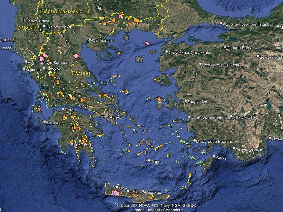
Greece’s fragmentation index is half than that of Europe, but it is growing faster. Specifically:

  • Greece was ranked in the first place of artificial land increase in Europe (2015)
  • Construction sites and roads consume more land in Greece than in Europe.
  • The road network of Greece has a length of more than 367,000 km, while the probability of being at a distance greater than one kilometer from any road is only 5.43%.
What is the relationship of roads with biodiversity loss?

Roads facilitate the transport of people and goods and are directly linked to enhancing economic development locally and nationally.

Despite the significant benefits of having a useful road network, roads are related to the top five causes of biodiversity loss worldwide, which are in descending order of severity:

  • Land use change
  • Direct natural resources exploitation
  • Climate change
  • Pollution
  • Invasive species

Roads are therefore considered to be one of the main causes of biodiversity loss and ecosystem degradation worldwide, especially when penetrating natural ecosystems and formerly undisturbed areas.

The habitats of species are shrinking, populations are isolated, wildlife mortality from vehicle collisions on the road network is increasing.

At the same time, all the ecosystem services associated with the soil, such as decomposition, or nitrogen cycle, are lost, as the soil is sealed and converted into artificial land.

Human health is indirectly affected through the increase of pollution and the facilitation of the spread of diseases.

Why are “Roadless Areas” a matter of global interest?

We live in an unprecedented time of biodiversity crisis. The sixth mass extinction of species in Earth history, attributed to anthropogenic causes, has begun, and at least 70% of the earth has been degraded, posing a serious threat to human well-being.

At the same time, we live in a time of culmination of the expansion of artificial surfaces and especially of roads.

The length of the new paved roads is expected to increase by 59% by 2050.

Top scientists consider road construction as the worst threat to the planet for the loss of biodiversity, and therefore the preservation of Roadless Areas as the key policy to halt the loss of biodiversity.

This new trend of conservation of Roadless Areas has now been embraced by global societies (SCB, IUCN, UNEP, Conservation International, Tebtebba) and the issue has taken global dimensions at the United Nations Summit on the Convention on Biological Diversity (COP 11, India. and in Rio + 20, Brazil, 2012).

Is there a statute of “Untrodden Mountains” in the EU?

Greece becomes the first country in Europe to institutionalize “Untrodden Mountains”.

 The issue of natural land fragmentation was considered to be one of the greatest challenges in the EU in the vote of the European Parliament on 08/06/2021 for the new Biodiversity Strategy 2030, entitled “Return of Nature to our lives”, which took place in early June. Besides, the obligation to assign a strict protection regime to at least 10% of the territory of each country was voted.

The European Commission has put forward a proposal for legally binding EU restoration targets in 2021. The restoration of EU ecosystems will contribute to enhance biodiversity, mitigate and adapt to climate change and prevent and reduce the effects of natural disasters.

The main objective of the EU initiative is to restore degraded ecosystems, especially those with the greatest potential:

  • Carbon capture and storage.
  • Prevention and reduction of the effects of natural disasters.
  • Soil health and pollination.
  • Improving the knowledge and monitoring of ecosystems and their services.

With the institutionalization of the Untrodden Mountains, we proactively follow this restoration policy.

“Roadless Areas” conservation first began in 2001 in the United States under the title “The Roadless Rule” and is currently being studied by the European Union to be integrated into the objectives of the Green Agreement.

With what goals are “Roadless Areas” harmonized?

Roadless Areas contribute to the achievement of 12 objectives of the National Biodiversity Strategy such as:

  • Preservation of the national physical capital (objective 2.1).
  • Delineation of ecological corridors (objective 3.3).
  • Enhancement of the synergy of key sectoral policies by conserving biodiversity and establishing incentives (targets 5.1-5.8).
  • Conservation of landscape diversity (objective 6.2).
  • Dealing with invasive alien species (objective 8.2).

Furthermore, based on the recent United Nations National Assessment Report on the Sustainable Development Goals, eight national priorities were set by the General Secretariat of the Government for Agenda 2030.

The designation of the extended RAs and their introduction in the spatial planning of the country, is documented as a positive contribution to the achievement of three Sustainable Development Goals:

  • Responsible consumption and production (goal 12).
  • Climate action (goal 13).
  • Life on land (goal 15)

In the context of the 6th national priority under the title: “Strengthening the protection and sustainable management of natural capital as a basis for social prosperity and the transition to a low carbon economy”

Finally, Roadless Areas are in line with the European Landscape Convention, as ratified by Greece, according to which the landscape is “a key component of the European natural and cultural heritage”.

FROM THE PRESS OFFICE

Each Ministerial Decision is structured as follows:

Title

Terms and restrictions for the roadless area of the mountain [..name of the mountain]

The vice minister of Environment and Energy takes into consideration… a list of legal and other official documents is inventoried, referring also to our Roadless project as well as to the suggestions from the General Directorate of Environmental Policy of the Ministry of Environment and Energy (attached document in Ministerial Decisions section).

Article 1: Goal

The first article of all Ministerial Decisions presents the goal of the legislation, as follows:

“The purpose of the present is the effective protection of the habitat types and the flora, wild fauna and bird species and their habitats of the roadless area [name of the roadless area] through the institutionalization of special conditions and restrictions.

In particular, the following is sought:

(a) halting land-use change, which is the leading cause of biodiversity loss at global and European level;

(b) halting the expansion of artificial land and the fragmentation of natural ecosystems by roads and artificial surfaces, and their associated negative impacts on biodiversity;

(c) the conservation of the habitat types and the species of flora, wild fauna and avifauna occurring in the area;

(d) the preservation of the natural, cultural, historical, aesthetic and other values of the landscape as defined in the European Convention on Landscape;

(e) the preservation of mild traditional anthropogenic activities which do not disturb natural ecosystems and their natural evolution;

(f) the development of nature-loving, trekking, mountaineering, and ecological tourism in areas of high natural and aesthetic value compatible with the above individual objectives; and

(g) the institutionalization of conditions and restrictions to ensure the harmonious coexistence of man and nature in the context of mild and sustainable development.”

Article 2: Designation of the area that the decision applies

In the second article, the boundary of the roadless area is presented, followed by a map in Appendix 1, and by a table with the exact coordinates (Greek Grid) in Appendix 2, its area in square kilometers, and its elevation range (meters). The sites of the Natura 2000 network with their codes that overlap with the roadless area are also presented. The last paragraph stresses the importance of the area as an undisturbed natural area without roads accessible by motorized vehicles and other artificial surfaces.

Article 3: Terms and restrictions

The third article presents the restrictions and conditions in the roadless area defined in article 2 as follows:

“In the whole area of Article 2:

(1) It is prohibited the construction of roads accessible by motor vehicles, regardless of category, and any kind of technical intervention, alteration or deterioration of the natural environment.

(2) From the present, legally existing projects and their maintenance are not affected.

(3) In particular, marking, repairing, maintaining and improving existing mountaineering and hiking trails is allowed, without the use of motorized means of access and provided that the interventions will be implemented with natural materials.

(4) Projects for the purposes of National Defense, as determined in accordance with the provisions of current legislation, are exempted from the terms and restrictions of this.

(5) Exempted from the above prohibitions:

(a) projects and interventions implemented due to emergencies (earthquakes, floods, natural disasters, fires, etc.) if care is taken afterward to restore the environment.

(b) projects and interventions deemed necessary for reasons of protection and/or restoration of the natural and forest environment.”

Article 4: Control-Penalties

The article presents shortly the implementation of the Ministerial Decision as follows:

(1) The control of compliance with the provisions of this and the confirmation of any infringements for enforcement sanctions shall be made by the competent authorities on the basis of current legislation.

(2) The guarding and supervision of the area are implemented by the competent bodies.

Article 5

The article quotes “The validity of this decision starts from its publication and lasts for two (2) years.”

Appendices

The legislation includes Appendix 1 ( map of the roadless area) and Appendix 2 (coordinates of the roadless area)

For each roadless area, you can download: (a) the official ministerial decision as published in the governmental journal (FEK), (b) the suggestion signed from the General Directorate of Environmental Policy of the Ministry of Environment and Energy, and (c) the map of the roadless area as a kmz file (Google Earth). All such files are available to download in this google drive “FEK_6_Roadless Areas” [It is dynamically updated with new legislation when published].

Media

This section lists articles of the international or national/ local press referring to the scientific findings of our research. The articles are indicative and are quoted without necessarily reflecting the opinion of BCL. The media coverage of our research is an indicator of the impact of our research on society.

10/2/2022: DNR- Dachverband der deutschen Natur-, Tier- und Umweltschutzorganisationen. Mit gutem Beispiel voran: Griechenland beschließt “straßenlose Zone” [German]

28/1/2022:  Paweł Wernicki. Nauka W Polsce. Grecja chroni swoje bezdroża [Polish]

24/2/2022. Τ. ΣΑΡΑΝΤΗΣ. Η εφημερίδα των Συντακτών. “Απάτητα Βουνά” μόλις το 1% των ορεινών εκτάσεων.

6/2/2022. Η εποχή. Έξι απάτητα βουνά, τα άλλα καταπατημένα

21/1/2022. CNN Greece. «Απάτητα Βουνά»: Σύσκεψη υπό τον Μητσοτάκη για την περιβαλλοντική θωράκισή τους

21/1/2022. Ελεύθερος Τύπος. Μητσοτάκης: Εξι «Απάτητα Βουνά» χωρίς ανεμογεννήτριες – Η άλλη όψη του αναπτυξιακού μας προγράμματος

21/1/2022. Έθνος. Έξι βουνά της χώρας σε καθεστώς πολύ αυξημένης περιβαλλοντικής θωράκισης – Τι είπε ο Κυριάκος Μητσοτάκης

21/1/2022. Καθημερινή.  «Απάτητα βουνά»: Παρουσιάστηκε το σχέδιο.

21/1/2022. Πρώτο ΘΕΜΑ. Μητσοτάκης για «Απάτητα Βουνά»: Μπαίνουν σε καθεστώς αυξημένης περιβαλλοντικής θωράκισης

21/1/2022. Το Βήμα. Μητσοτάκης: Το project «απάτητα βουνά» είναι η άλλη όψη του αναπτυξιακού μας προγράμματος

20/1/2022. Β. ΕΥΘΥΜΙΟΠΟΥΛΟΥ. Liberal. Μια πρωτοβουλία μοναδικής σημασίας

20/1/2022. Ριζοσπάτης. Προσπάθεια απόκρυψης της ληστρικής εκμετάλλευσης και καταστροφής των ορεινών όγκων

19/1/2022. CAPITAL. Για ποια αιολικά πρότζεκτ θα παραμείνουν “απάτητα τα βουνά”

19/1/2022. Α. ΧΑΤΖΗΓΕΩΡΓΙΟΥ. Η εφημερίδα των Συντακτών. Τα απάτητα βουνά και η περιφέρεια του Κ. Σκρέκα

19/1/2022. Ναυτεμπορική. «Απάτητα» 6 βουνά της χώρας: Ποια project ανανεώσιμων πηγών παγώνουν

19/1/2022. Καθημερινή. Ποια είναι τα ελληνικά «Απάτητα Βουνά»

19/1/2022. ΤΑ ΝΕΑ. Το νέο καθεστώς για έξι βουνά

16/12/2021. Energia.gr. Γιώργος Αμυράς στην Βουλή για “Απάτητα Βουνά” και Προστατευόμενες Περιοχές Νatura

24/11/2021: Γ. ΛΙΑΛΙΟΣ. Καθημερινή. “Απάτητα βουνά μακριά από δρόμους και τσιμέντο. Ο Γ. Αμυράς μιλάει στην Κ

22/12/2020: Γ. ΛΙΑΛΙΟΣ. Καθημερινή. «Οι πολλοί δρόμοι βλάπτουν τη φύση»

1/11/2021. Ομιλία του Πρωθυπουργού Κυριάκου Μητσοτάκη στη διάσκεψη των Ηνωμένων Εθνών για την κλιματική αλλαγή COP26 (Ανακοίνωση των Απάτητων Βουνών). Primeminister.gr

6/2/2022. Ελευθερία [Λάρισα]. Έτσι θα μείνει ανέγγιχτος ο φυσικός πλούτος της Ελλάδας

6/2/2022. Ρέθεμνος. [Κρήτη]. Αγία Ρουμέλη: Γιατί ζητά να εξαιρεθεί από τον θεσμό «Απάτητα Βουνά»

4/2/2022: Ευρυτανικός παλμός. [Ευρυτανία]. Θα γίνουν… ‘Απάτητα’ τα βουνά της Ευρυτανίας;

4/2/2022. Χ. ΜΕΓΑΣ. Μαχητής. [Άρτα]. Τα απάτητα και τα «σπαρμένα» με… ικριώματα βουνά μας

3/2/2022. The Best [Πάτρα]. Τα έξι “απάτητα” βουνά της Ελλάδας σε καθεστώς προστασίας

28/1/2022. Γ. ΧΑΛΑΤΣΗ. Ηπειρωτικός Αγών. [Ιωάννινα].  Άλλοθι για την αντιπεριβαλλοντική πολιτική τα «Απάτητα Βουνά»

19/1/2022. TheNewspaper.gr. Ποια είναι τα ελληνικά «Απάτητα Βουνά» – Φρένο σε επενδύσεις ΑΠΕ

22/1/2022 .Epiruspost.gr. [Ήπειρος] «Απάτητα Βουνά» με βάση την μελέτη της Κικής Κατή

19/12/2021. Β. ΑΓΓΕΛΗ. typos-i. [Ιωάννινα]. Στα «Απάτητα Βουνά» της Τύμφης και του Σμόλικα (κι όχι μόνο)

25/12/2020: Ρέθεμνος. [Κρήτη] «Απειλή για το περιβάλλον η διάνοιξη δρόμων στα Λευκά Όρη» 

24/12/2020: Ηπειρωτικός Αγών. [Ιωάννινα] «Αντιστέκονται Τύμφη και Σμόλικας στην κατάτμηση από δρόμους» 

23/12/2020. Epirustvnews. [Ήπειρος]  «Κ.Αρσένης: Υπό Εξέταση Η Προστασία 6 Βουνών Της Ελλάδας Από Άναρχα Αιολικά Λόγω Της Σημασίας Τους Για Την Βιοποικιλότητα» 

21/2/2022. Β. ΚΑΤΗ. Η εφημερίδα των Συντακτών. Διάλογος για τα Απάτητα Βουνά. [Το άρθρο συνιστά απάντηση σε τοποθέτηση του κ. Γ. ΜΠΑΛΙΑ από 13/2/2022 με τίτλο: Τα “Απάτητα Βουνά” και οι ταπεινωμένες κορυφές. Ένθετο  Νησίδες της εφημερίδας των Συντακτών]

12/2/2022. BCL dasarxeio.com Απάτητα Βουνά: Διαφάνεια και διάχυση της επιστημονικής γνώσης.

6/2/2022. Θ. ΑΡΑΜΠΑΤΖΗΣ. Ελευθερία [Λάρισα]. Έτσι θα μείνει ανέγγιχτος ο φυσικός πλούτος της Ελλάδας [Συνέντευξη Β. Κατή/ BCL]

3/2/2022. Γ. ΓΚΟΝΤΖΟΣ. Δημοτικό ραδιόφωνο Ιωαννίνων. Συνέντευξη για τις Περιοχές Άνευ Δρόμων. [ηχητικό αρχείο]

20/1/2022. E. ΚΩΝΣΤΑΝΤΙΝΙΔΟΥ. Εκπομπή Ο3 -ΕΡΤ. Τα έξι “απάτητα βουνά” της Ελλάδας σε καθεστώς προστασίας. [Συνέντευξη  Χ. Κασσάρα/BCL (you tube)].

17/3/2021. Πράσινες Ιστορίες – ΕΡΤ. Περιοχές Άνευ Δρόμων. Ντοκυμαντέρ με συνέντευξη της Β. Κατή. Σκηνοθεσία Β. Ευθυμίου. [βίντεο ertflix].

Το χρονικό των "Απάτητων Βουνών"

Impact of roadless legislation

Short review of the feedback of stakeholders on the Greek roadless areas legislation, including scientific societies, and NGOs.

SCB Europe Press Release: Greece gives legal protection to roadless areas.  27/1/2022. See here και here  

SCB Europe letter to the European Commission on roadless policy and fast renewable infrastructure development. 26/3/2021. See here  

NEMOR letter to the European Commission on “Need for European mountainous landscapes conservation through a roadless policy”. 12/7/2022. See here 

WILD EUROPE: Greece leads the way to roadless protection. See here

26/1/2022: Hellenic Ecological Society. Announcement

27/1/2022. Hellenic Zoological Society. Announcement.

9/2/2022. Hellenic Ornithological Society. Announcement 

9/2/2022. Announcement of 11 Greek NGOS: ΑΝΙΜΑ, Arcturos, Elliniki Etairia-Society for the Environment and Cultura Heritage,  Hellenic Society for the Protection of Nature, Callisto, Ecological Recycling Society, Greenpeace, MEDASSET, Mom, WWF

News

News on the WIND project, including notifications of new material published, articles in the press and other media, relevant policy impact and feedback from society are posted in the BCL facebook page. Selected news are posted here (See Science for Society posts  – tag: wind)

Γρήγορη αναζήτηση