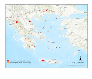
RA: The Roadless Area is any land patch (polygon> 1 sq.km.) that is at least one kilometer away from the nearest road. Each Undisturbed Natural Area (UNA) includes the polygon of the RA and a buffer zone of 1 km aroun it. Therefore the UNAs depicted on the map are landscapes of great ecological, natural and aesthetic value which are not intersected by roads in their entire extent. Red colour shows the 7 very large areas of UNA containing RA> 50 sq. km. With orange colour 39 large UNAs that include RAs 10-50 sqkm. Only the undisturbed natural areas that completely or partially overlap with the Natura 2000 network are shown. Mapping is in progress for all of them inside and outside the Natura 2000 network.
The NATLAND project – Undisturbed Natural Areas of Greece (SEBI 13) -was included in the financing of the axis “Natural Environment & Innovative actions” of the Green Fund in June 2021, as a continuation of the ROADLESS project. The project is implemented in the Biodiversity Conservation Laboratory of the Department of Biological Applications and Technologies of the University of Ioannina (BCL), led by Prof. V. Kati and the participation of an eight-member research team. The results of the research are going to be regularly uploaded to the lab website under ROADLESS. On the initiative of the Prime Minister of Greece Mr. K. Mitsotakis, institutional shielding of UNA is imminent from the non-opening of new roads, as announced at the COP26 summit under the emblematic title “ Untrodden mountains“, and as also confirmed by the Deputy Minister of Environment Mr. G. Amyras in an interview with Kathimerini.
